Checking for non-preferred file/folder path names (may take a long time depending on the number of files/folders) ...
This resource contains some files/folders that have non-preferred characters in their name. Show non-conforming files/folders.
This resource contains content types with files that need to be updated to match with metadata changes. Show content type files that need updating.
| Authors: |
|
|
|---|---|---|
| Owners: |
|
This resource does not have an owner who is an active HydroShare user. Contact CUAHSI (help@cuahsi.org) for information on this resource. |
| Type: | Resource | |
| Storage: | The size of this resource is 22.3 MB | |
| Created: | Nov 08, 2021 at 11:52 a.m. (UTC) | |
| Last updated: | Nov 11, 2021 at 8:41 p.m. (UTC) | |
| Citation: | See how to cite this resource |
| Sharing Status: | Public |
|---|---|
| Views: | 4245 |
| Downloads: | 243 |
| +1 Votes: | Be the first one to this. |
| Comments: | No comments (yet) |
Abstract
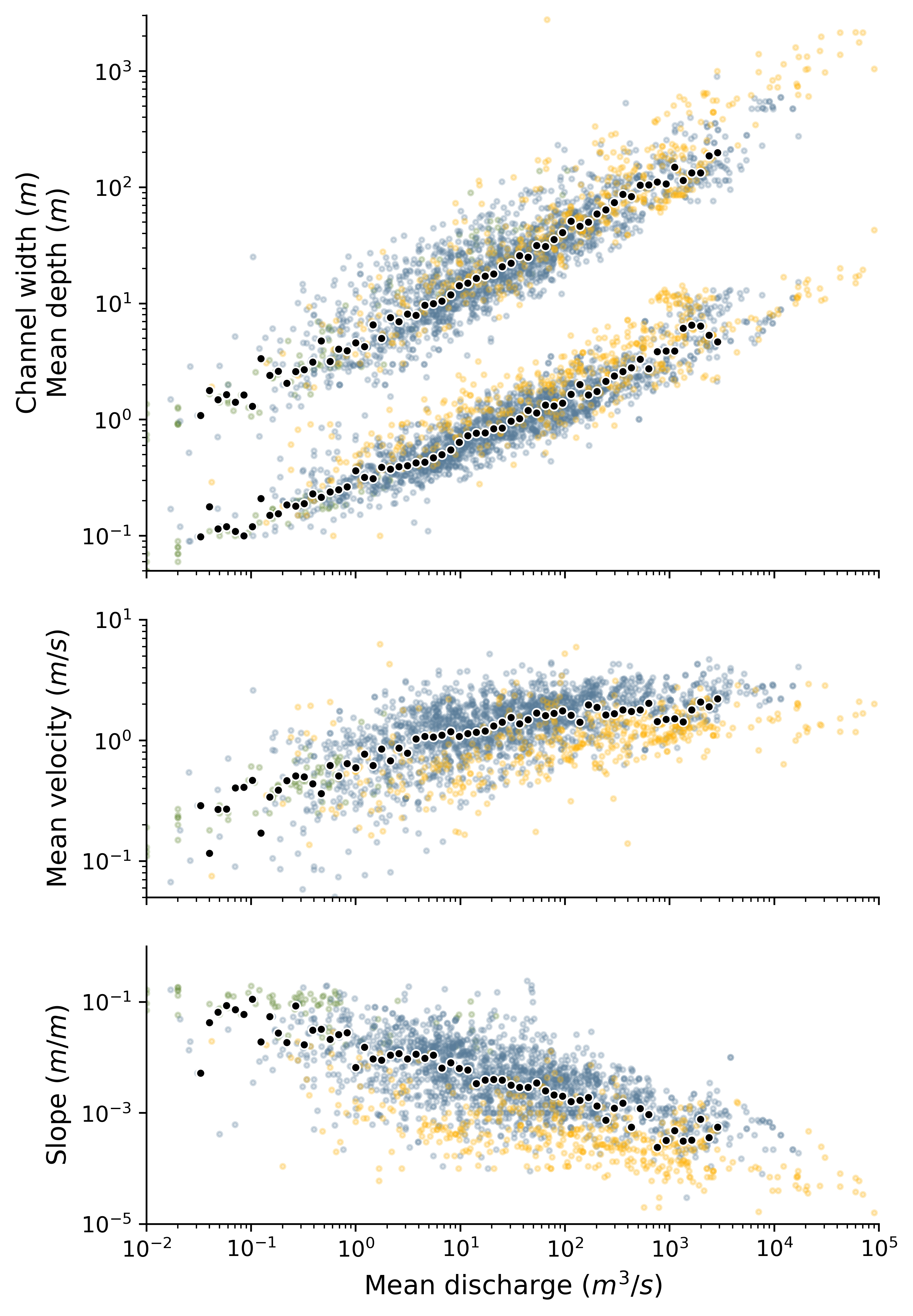
A compilation of paired flow depth, flow width, flow velocity, discharge, channel slope and grain size data for river channels ranging from coarse steep bedrock rivers to large fine-grained alluvial rivers. Includes both bankfull and non-bankfull measurements. The dataset is in large part composed of the data compilation of Rickenmann and Recking, 2011 (doi :10.1029/2010WR009793), the bankfull bedrock channel width dataset of Dibiase’s thesis (can be found on his personal website), plus some other minor sources. I also include the recent dataset of bankfull alluvial hydraulic geometry from Phillips, 2021 (www.hydroshare.org/resource/fa5503b04af343ffbaf33d5a15cb2579) to ensure I can remove overlap between that dataset and the other sources of data used.
Subject Keywords
Content
readme.md
Dataset description
Eric Deal, 11.2021
A compilation of paired flow depth, flow width, flow velocity, discharge, channel slope and grain size data for river channels ranging from coarse steep bedrock rivers to large fine-grained alluvial rivers.
File description
-
‘HG_data_comp_complete.csv’ is a compilation of all paired measurements in the dataset.
-
‘HG_data_comp_simplified.csv’ is a subset of the complete dataset made by taking the average of all paired measurements for a given channel reach. Many of the datasets made not at bankfull conditions consist of ~20 measurements of the same reach at different discharges. So as to not weight averages over the entire dataset too heavily in favour of these sites, I take the average of all the measurements at a given reach.This doesn't give the bankfull hydraulic geometry, but it gives a characteristic hydraulic geometry for a characteristic discharge.
-
‘data_compilation.py’ is the python script used to homogenize and compile various data sources. It contains detailed information on how the data were processed.
-
‘cleaned_source_data’ is a folder containing the csv files I complied from each primary source. The data are well organized and relatively cleaned, but not homogenous: e.g. field names and units vary from file to file.
-
‘uncleaned_source_data’ contains the original files, tables, and pdfs I sourced all the data from. I provide it in the interest of openness, but I make no assurances on the quality or completeness of the files in this folder.
Points to note:
-
Not all measurements are at bankfull, in fact many are not. Whether a measurement is at bankfull or not can be discerned from the field ‘bankfull’. More information can be found in the python script used to compile data ‘data_compiliation.py’, or in the primary data sources.
-
D84 is not always available, when not, it is estimated as 2.2xD50.
-
Velocity is not always measured, when not, it is estimated as discharge / (width x depth)
-
The Dibiase dataset is a valuable dataset of bedrock river widths, covering a regime with little data. However, there are several important caveats associated with the data:
- The dataset consists of 2400 measurements of bankfull width over a relatively small region, and it is not clear how to group the data into averages. To avoid the dataset biasing effect described above for the simplified dataset, one may wish to exclude the Dibiase data when taking averages of the entire data cloud.
- The D50 measurements are approximate. Here is the description from the source:
- "I estimated D50 by eye, intermittently calibrating these observations with more detailed point counts (50 total point counts, see Chapter 4 for details). For early surveys, grain size estimates were made qualitatively (e.g., gravel, cobble, boulder); in later surveys I switched to estimating grain size to the nearest 1⁄2 phi size. For ease of comparison, I converted qualitative survey results to numeric using the following conversion: sand = 2 mm; pea gravel = 11 mm; fine gravel = 22 mm; coarse gravel = 45 mm; cobble = 90 mm; small boulder = 256 mm; medium boulder = 512 mm; large boulder =1024 mm. These converted estimates, which should be interpreted with caution, are marked in the data table by a star. In particular, the range of clast sizes covered by the “cobble” classification is quite large."
- The bankfull discharge is estimated from catchment area using Q_bf = k_b A^a, where discharge in units of m^3/s and area in units of km^2 and where k_b = 0.072 and a = 0.97 are the mean of the same parameters from three studies in regions with similar precipitation rates to the San Gabriels (0.6-0.8 m/yr):
- "Determination of Channel-Morphology Characteristics, Bankfull Discharge, and Various Design-Peak Discharges in Western Montana, Lawlor 2004"
- "Sediment Transport Data and Related Information for Selected Coarse-Bed Streams and Rivers in Idaho, King 2004"
- "Estimated Bankfull Discharge for Selected Michigan Rivers and Regional Hydraulic Geometry Curves for Estimating Bankfull Characteristics in Southern Michigan Rivers, Rachol, 2009"
-
All data in the two files ‘HG_data_comp_complete.csv’ and ‘HG_data_comp_simplified.csv’ are in SI units. Specifically:
- ‘width': meters,
- 'depth': meters,
- 'velocity': meters/second,
- 'd50': meters,
- 'd84': meters,
- 'slope': meters/meter,
- 'discharge': meters^3/second,
- 'area': meters^2,
- 'sed_discharge': kilograms/second,
- 'd90': meters,
- 'bedload_discharge': kilograms/second,
- 'erosion_rate': mm/yr
- 'river_class': -1 = bedrock, 0 = gravel bedded, 1 = sand bedded
- 'bankfull': True or False,
- 'source': source where I found data,
- 'DOI': DOI of source, if available,
- 'primary_source': original data source if I took it from a compilation,
- 'site_id': name of river reach, if given,
Plot of datast (channel widths are always larger than channel depths):
Credits
Contributors
People or Organizations that contributed technically, materially, financially, or provided general support for the creation of the resource's content but are not considered authors.
| Name | Organization | Address | Phone | Author Identifiers |
|---|---|---|---|---|
| Colin B Phillips | Utah State University | Utah, US | 7072935114 | |
| Dieter Rickenmann | Swiss Federal Research Institute WSL | |||
| Alain Recking | INRAE, UGA, UR ETNA |
How to Cite
This resource is shared under the Creative Commons Attribution CC BY.
http://creativecommons.org/licenses/by/4.0/
Comments
There are currently no comments
New Comment